Probing the Australian-Pacific Plate Boundary (Pt 7: The hunt for MRO21)
The period of extremely bad 48 hours of weather was approaching, and I had high hopes that we would be able to complete two more sites before high swell hits us and completely puts us out of action.
The site MRO21 (Macquarie Ridge Ocean 21) was no different from other deployment sites on this voyage. A strong wind of nearly 40 knots, the Antarctic Circumpolar Current (ACC), and the 5-meter swell meant that we had to calculate our drop position precisely for the ocean bottom seismometer (OBS) to land onto their desired location - preferably void of steep slopes. Indeed, it took long hours of charting, a careful site selection, and a consideration of all possible factors, including the ACC strength at this site, to calculate the exact drop location.
We previously abandoned a wire descent because of a high risk that a heavy acoustic transponder (100 kg), mounted just above the OBS (250 kg) on the wire could damage it at the moment it touches the ocean’s restless surface. We realized that due to the OBS’s buoyancy and vigorously moving water mass, it was impossible to avoid one clashing to the other, which could damage sensitive parts, activate the release mechanism or cause the instrument to prematurely drop its anchor. We originally wanted to sink our OBSs on a wire and release them about 50-100 m above the ocean floor. On one hand, that would have saved precious time that has to be spent on locating them on the ocean floor by a triangulation method, but on the other hand that meant that we had to wait for 500-1000 kg of wire to get coiled back on the ship’s winch. The decision was to go with a free-fall method instead, relying on our ability to hit the desired spots. This meant that we had to perform the triangulation every time.
It was still relatively early in the afternoon when the technical and science crew in the ops lab, who watched the live stream from the deck where the suspenseful action was unraveling, were greatly relieved that another instrument finally touched the water surface and was on its way down. The bathymetry for that particular location read 4785 meters, and with the descent rate of about 35 m per minute, we were expecting a touchdown of MRO21 in about 2 hours and 15 minutes.
The beeping that was coming from one of the sonar-system deck boxes in the ops room sounded reassuring. It meant that we could successfully communicate with MRO21 during its descent. You can track it during its descent at the frequency of 11 kHz, and when the range for several consecutive signal exchanges becomes negligibly different, it is a sign that the instrument landed. At the same time, both the ship and the OBS on its way down were drifting laterally from the position in which the OBS was dropped, each at their own rate and in different directions, which meant that we were not directly above the instrument any longer. I remember the last reading on the deck-box screen was about 5500 m and still dropping. The difference between two consecutive readings gradually became smaller and I felt relieved because MRO21 most likely reached the ocean floor. I enthusiastically started checking the route to our next site to prepare the most time-efficient triangulation route for the ship.
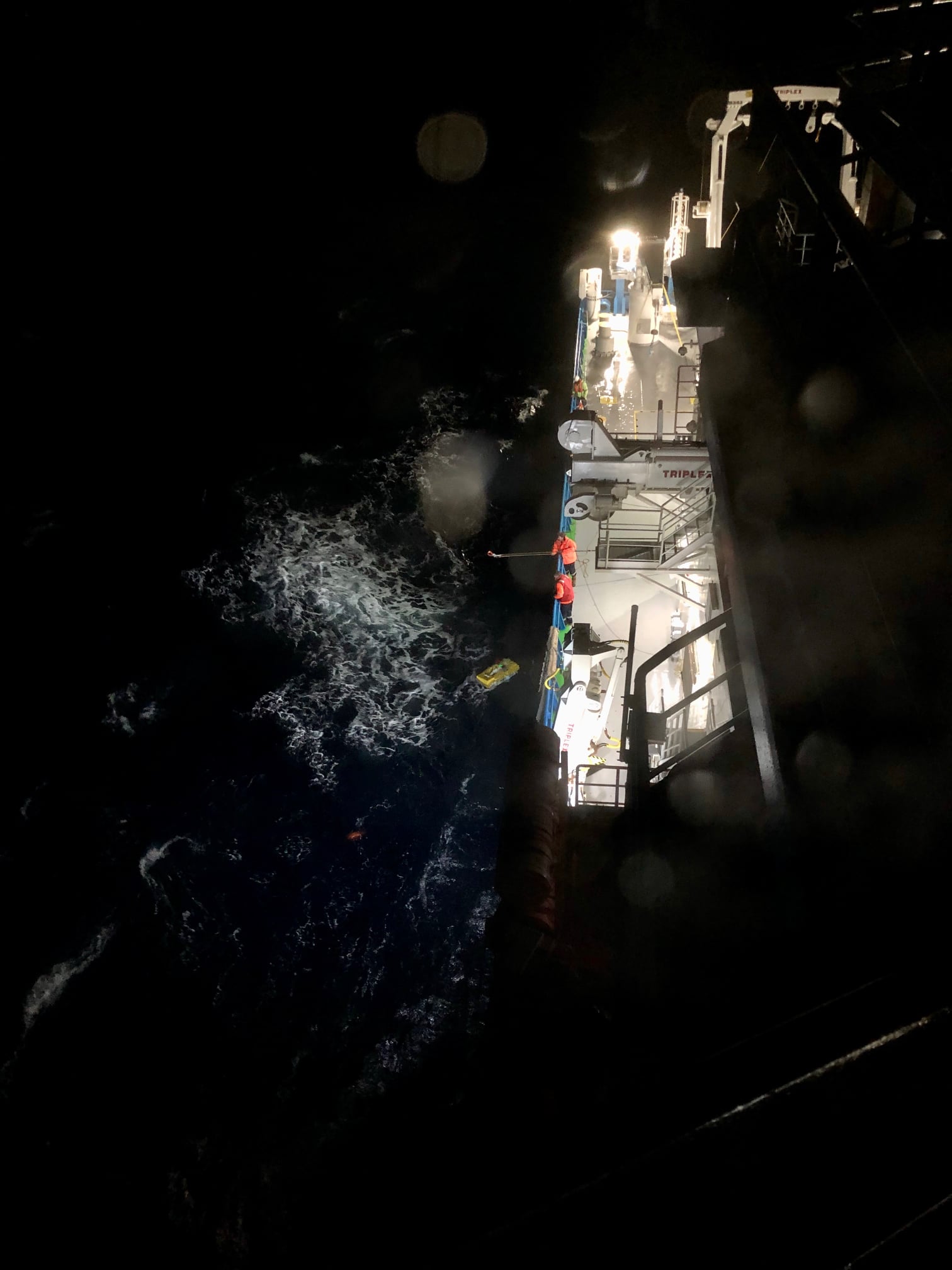
“It’s coming back,” said Andrew, head of RSES electronic workshop, whose expertise and diligence on this voyage was irreplaceable. Stunned for a moment, I looked at the range and it was now clearly dropping, which could only mean one thing: our OBS unit, unfortunately, bounced back from the ocean floor and was ascending. I glanced through one of the bull’s-eye windows, through which I was watching the waves and the horizon during our time in the science lab. With the last daylight fading away, I knew it was going to be a long night. A low-frequency sound of breaking waves was mixing with the silence. Our hunt for MRO21 began.
Andrew issued a release command about 40 minutes later. This is the command that is used to release the ballasts (the anchor) and activate a flashing light on the OBS sensor. In this case, the ballasts were already gone, so the command only activated flashing. We knew that the ascend rate was about 50 m per minute. This gave us a good idea of when the instrument will surface, but we still didn’t know at which location exactly. We kept ranging the instrument until it was very close, at first a bit over 2000 m, and, eventually, coming close to about 750 m. This was a tricky operation involving the addition of the vectors of the ship velocity over the water and the ocean current velocity, and quickly communicating updates to the bridge. We had to track the OBS, but at the same time avoid coming too close because the ship needed some time and space for a maneuver in these formidable weather conditions. In case we would come too close to the instrument and pass it, it would take a too long time to turn the ship and we would possibly lose our OBS due to its strong drift to the west. It was a bit like a cat-and-mouse game.
The ship acoustic transponder is under the water surface, and only able to communicate to the OBS receiver while it is still under the water. As soon as MRO21 stopped responding to the calls, we knew that it was on the surface. Almost instantaneously, “the bridge” gave us a call to let us know that they spotted the OBS flashing light.
I rushed up the stairs to the bridge command room, which is six levels above the lab. I entered an open space of the bridge command room that was in complete darkness. Only the screens of the console units that were arranged in semi-circular fashion were lit. The overall design of the bridge is impressive, with extended wings that give the captain and the mates an unrestricted region of visibility so that they can control the entire operation of the vessel. The captain was there with one of his mates, pointing to a flashing light in the darkness of the night. Although it was the full moon that night, it was overcast, and this worked well for us. The full moonlight would reduce our ability to spot the flashing light.
From the last reading of the deck box, I knew that the distance to the OBS was about 700 m, but just by looking at it, it was impossible to estimate how far it was because the flashes were constantly changing their direction due to the wavy ocean surface. The westerly current was about 2 knots, and the captain had to react quickly to stay close to the OBS. He lowered the bow thruster to increase the maneuvering ability of the ship and started approaching the target. He then shut the propellers to avoid the OBS getting drawn under the ship from the starboard side from which the recovery operation was going to take place. The approach lasted about 25 minutes. When the ship turned around, the OBS path was aligned along the starboard side of the deck, with its custom-made, complex-curvature hook, upward. The long rods that the deck crew were operating required a lot of effort and skills. It is hard to hold those rods steady in such extreme weather conditions but they did an incredible job to finally capture the OBS hook. Finally, the OBS was trailed backward and brought to the back deck by an A-frame winch around 10:40 local time.
I witnessed great relief from everyone involved in this operation. What a night that was! In retrospect, the entire operation served as a prototype of the recovery that we can expect next year when we return to collect our instruments and data.
At the time I am writing this, we have almost completed our charts, and only 6 OBSs remain to be deployed in the spots that we charted and selected. The weather is finally merciful (down to about 20 knots) and with some luck, we should be making our 75-hour journey back to Hobart sometime during the Friday night.