Probing the Australian-Pacific Plate Boundary (Pt 3 — A voyage to the furious fifties)
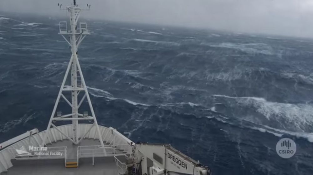
“Below 40 degrees south there is no law, and below 50 degrees south there is no God.” (Old Sailors' Saying)
So we departed Hobart yesterday at 1pm local time, heading south. Our destination is the location where the ocean bottom seismometers (OBS) will be sunk to the ocean floor over the area of about 1,000 square kilometers near the Macquarie island.
Spending a rough first night in the middle of the “roaring forties”, I am thinking about how our days will look like when we reach the fifties. Long feared for the wild seas and the destruction they could inflict, these geographical latitudes got their names at the time the first shipping routes were established. In fact, they shaped those routes.
Hot air that rises at the equator and travels outward around the earth, starts sinking back towards the earth’s surface at the latitudes of 30 degrees (Hadley cell) and continues traveling towards the south pole along the surface (Ferrel cell). Because of the Earth’s rotation, the air traveling between 30 and 60 degrees latitudes gradually turns into the westerly wind (from west to east). This westerly wind is particularly strong in the southern hemisphere because there are no large continental masses like in the northern hemisphere, to block its passage around the globe. It helps to develop the strongest oceanic current on the planet, where 25 million cubic meters of water per second at a typical rate of 4 km/h are being transferred from west to east around Antarctica – known as Antarctic Circumpolar Current. And we are going to the middle of it.
I will talk about the main goals of our experiment in the next post: why the Macquarie Ridge was chosen out of all the places where we could go, what we are hoping to find there and what the desired outcome of this project is. Here, however, I would like to say a few words about the travel and logistics of the deployment itself.
You have seen in the previous post that we are carrying two types of OBS instruments. Their capacity to record ground motion is similar, but their design is quite different. There are no many manufacturers of these instruments in the world, simply because demand is low. There have been a number of the previous deployment in different parts of the world, but this is the first such undertaking led exclusively by the Australian academics, seismologists and marine geophysicists, in a collaboration with our colleagues from the University of Cambridge and Caltech.
To top 17 Australian instruments, the University of Cambridge is contributing 12 more – thus making the total number 29.What needs to happen before we start sinking these 29 instruments to the abyss, one by one, is swathing of the ocean floor. Given that the ocean floor relief is not well known in this part of the world, we will first spend several days swathing using a mutibeam sonar for each of the four quadrants we are going to. The ridge is sloping down steeply from above the sea level where the Macquarie island is exposed to a depth of 6000 meters. We will be looking for rare sediment patches to ensure that the OBSs are coupled to the ground smoothly.
The maps of the ocean floor that will become available in real-time will allow us to select sinking sites for our OBSs, hopefully not too far from their originally desired locations. Given that the swathing will be in lines parallel to the Macquarie ridge, we will be experiencing constant winds and waves from the west. The ship will thus roll but thanks to its modern auto-stabilizing system that uses ballast water in giant tanks combined with air valves to control the flow of water from one side of the ship to the other, we should be safe from rolling too steeply.The whole operation of sinking the instruments down, releasing them 50-100 m above the ocean floor to fall freely, determining their exact location, and making sure that they landed safely and started operating, might last about 4 hours depending on the depth and weather conditions.
The entire operation, and given the weather conditions, the uncertainty associated with the ocean floor relief, could be compared with landing instruments on the surface of another planet. I should also add that we work in two 12-hour shifts (the ship-time is expensive and the ship has to be in constant motion), and according to our tight schedule, the first OBSs are going down during the night time. This adds to the complexity of the operation.
The instruments have ballasts to help them sink down, an acoustic release mechanism, and floats to help them return to the surface next year when we come to collect them. We sincerely hope that the return rates will be high, but given the weather and ocean floor relief conditions, we have to be prepared that some of them will stay on the ocean floor forever. It is hard to think about a more challenging place on the planet for this operation. But the science that awaits us helps remove any doubts and obstacles from our way.